TIDES
In this section we’ll focus on the tides influence on safe swimming practices and swim planning. You could talk about tides all day long, so we’ll keep this swim specific.
TIDE SIZE :
Simply put, tides are created by the gravitational pull of the moon and sun on the world’s oceans. When the earth, moon and sun align, we experience a stronger pull and larger tides - Spring Tides. During Spring Tides a greater mass of water moves in and out, between high and low tides. Spring high tide typically take place early morning and late evening. With this greater mass of water movement, comes greater potential for currents and possibly less safe swimming conditions.
Neap tides occur when the gravitational pull of the moon and sun aren’t in alignment. In terms of water activity, this means less water moving in and out, with the tides. So you’re more than likely looking at safer swimming conditions.
There are roughly 12 hrs and 25 minutes between high tides, so approximately 6 hours and 12 minutes from either high-to-low or low-to-high.
*A number of Apps out there (we use Nautide), have a ‘tidal coefficient’ feature. This scores the tidal size from 0-120 (120 being the largest Spring Tide possible). This is a really useful tool, as tidal size varies from area to area ie. Newquay and Portscatho in Cornwall are around 20 miles apart, a large high tide for Newquay can be 7.5m, where Portscatho would be 5.5m.
We spoke to Tom (from Sea Swim Cornwall) and he always suggests swimming on an incoming tide, if you’re swimming a route that isn’t tried and tested. At least that way you’ll struggle to get out, rather than struggling to get in!
SLACK WATER :
Also known as ‘slack current’. Is a period of roughly an hour, where the tide has little to no tidal pull…so approx 30 minutes at the end of the incoming tide phase and 30 minutes at the start of the outgoing tidal phase. This can vary, depending on where you are, the influence of the land and rivers etc. This tide definitely varies when talking about tidal estuaries.
WATER MOVEMENT :
Rule of Twelfths describes how the mass of water moves from a low to high or high to low tide.
If we take the example of a high tide moving to low :
over the 1st hour 1/12 of the total water mass that drains out happens in the 1st hour,
over the 2nd hour 2/12 drain out, 3 & 4th hours 3/12, then we’re back to 2/12
over the 5th hour 2/12 and 1/12 over the last hour. So the largest tidal movement happens over both hour 3 and hour 4. *Remember that you’ll also have ‘slack water’ for approx 15 mins either side of a high or low tide, where there’s almost no water movement at all (in most areas).
As a general rule, you may look to avoid those middle 2 hours of an outgoing tide, as these experience the highest level of outgoing water movement.
FUNNELING / ‘TIDAL RACE’:
Focusses on the shape of the land/channel. If you have a narrow channel, you’ll often get stronger water movement through that channel. Once the tide starts to go out, you have a huge mass of tidal water ‘draining’ back through a narrow gap. This can create a strong current. This can happens with estuaries, harbour mouths, islands, rocky formations and long, narrow beaches. The technical terms is a ‘tidal race’. This is always worth some consideration, as the conditions can be flat calm and look safe…
PRACTICAL EXAMPLES
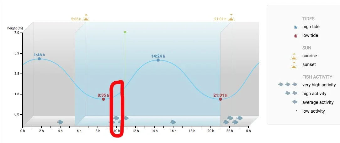
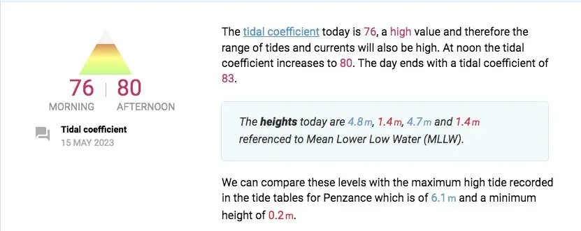
Below we’ve used Nautide/Tides4Fishing to demonstrate how you’d view the tide times online. So in the first image we’ve highlighted a planned swim at 10am. So low tide is clearly at 08.35 (with a tide tide at 14.24) and is a 1.4m tide. A quick look at the second image shows you that this is a Spring Tide and the morning high tide scores a 76. We’re swimming from approx 10-11am, which mainly covers that second hour of an incoming tide, so should be fairly safe (in theory anyway). You can see that the days second high tide is a 4.7m height, which may suggest that we’re moving from Spring Tides towards smaller Neap Tides.
The other factors to consider are regarding your swim should be :
Is there enough water at the beach, river, estuary…to swim. Low tides can expose rocks, muddy banks, limit access, expose seaweed etc.
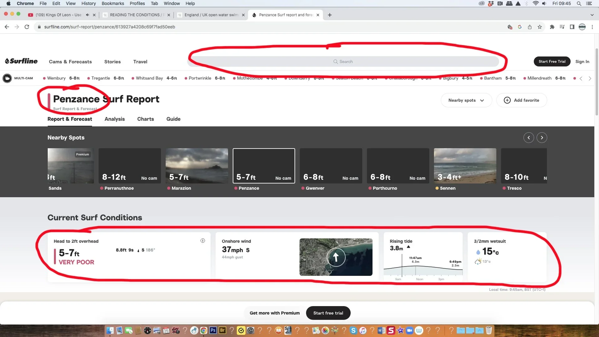
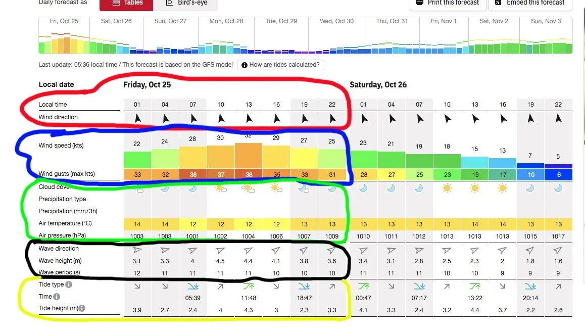
*Just to give you additional examples : Image 3 is from Surfline, where the tides are summarised towards the bottom of the page, using a brief graph (with high tide at 11.47 at 4.3m and low tide at 6.49pm at 2.3m). Image 4 is from the Windfinder website, circled in yellow you’ll see an hourly tide update, with the high and low tides highlighted and an indication of whether the tide in in-coming or out-going.