FORECASTING
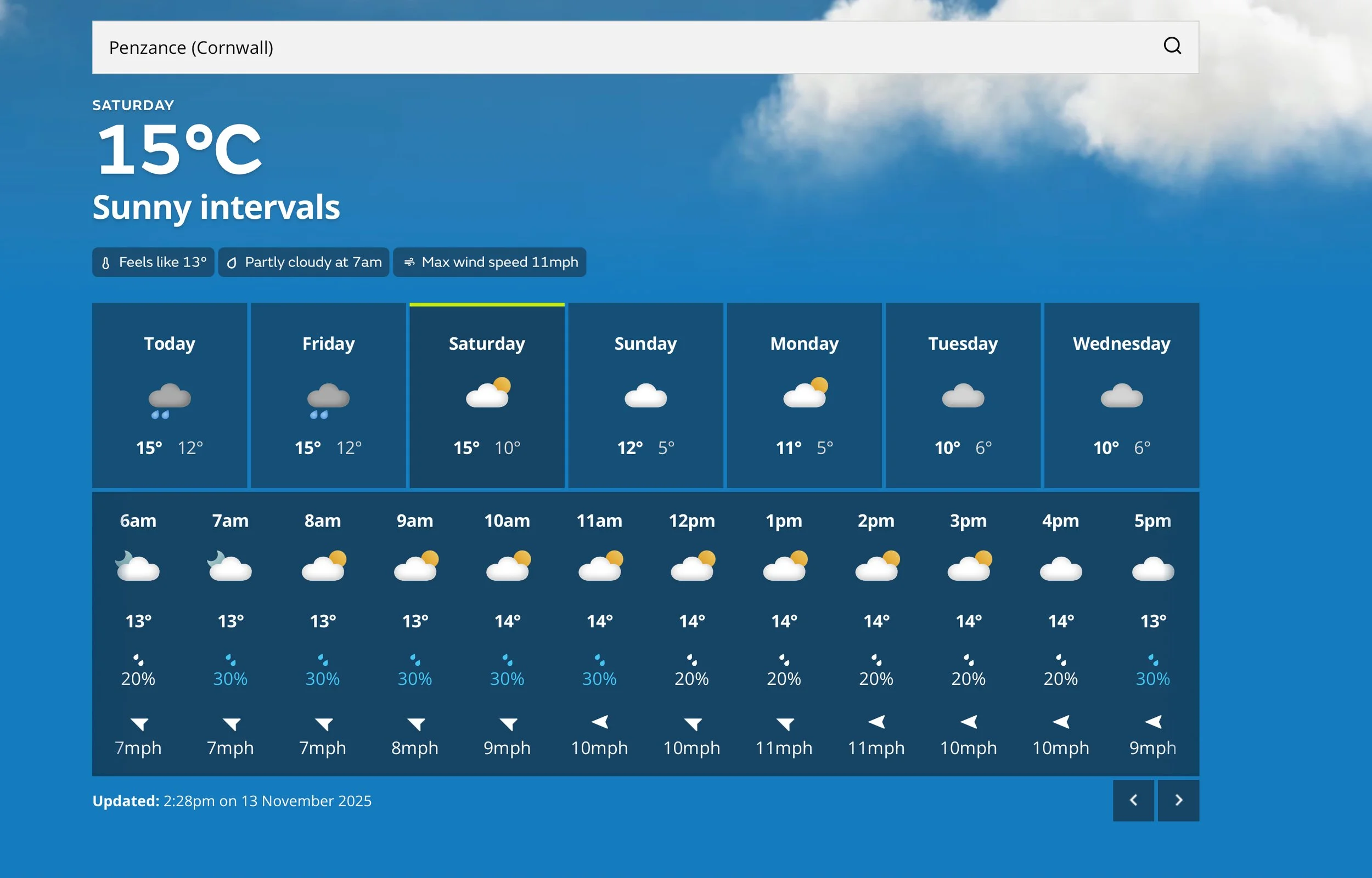
FORECAST : Easiest way to start is to simply look at the weather forecast. This will give you an idea of the predicted weather conditions, best time of day to swim, wind, rainfall, cloud cover, changes in the conditions, air temperature etc. Great habit to get into and this will dictate what you wear in terms of clothing, swimwear, tinted or clear goggles, sunblock, layers… It’ll also give you an indication of swimming conditions. As well as prompting you to check for potential water pollution, if required.
FORECASTING SOURCES ONLINE INCLUDE : Met Office weather, BBC weather, standard I-Phone weather App, Windy App, AccuWeather, NetWeather…
WE HAVE COVERED READING THE CONDITIONS AND FORECASTING IN THE SEA SWIMMING SECTION. WE’LL REPEAT THE INFO BELOW AND ADD MORE DETAIL.
There is an art to reading the conditions and planning a swim. It really isn’t a difficult art to pick up though, through practice and persistence. The longer you look at the conditions and get used to planning, the better you tend to get at predicting the likely swimming conditions.
Below, we’ll look at a specific swim and then how you’d go about checking the conditions and planning a route or possibly finding an alternative swim.
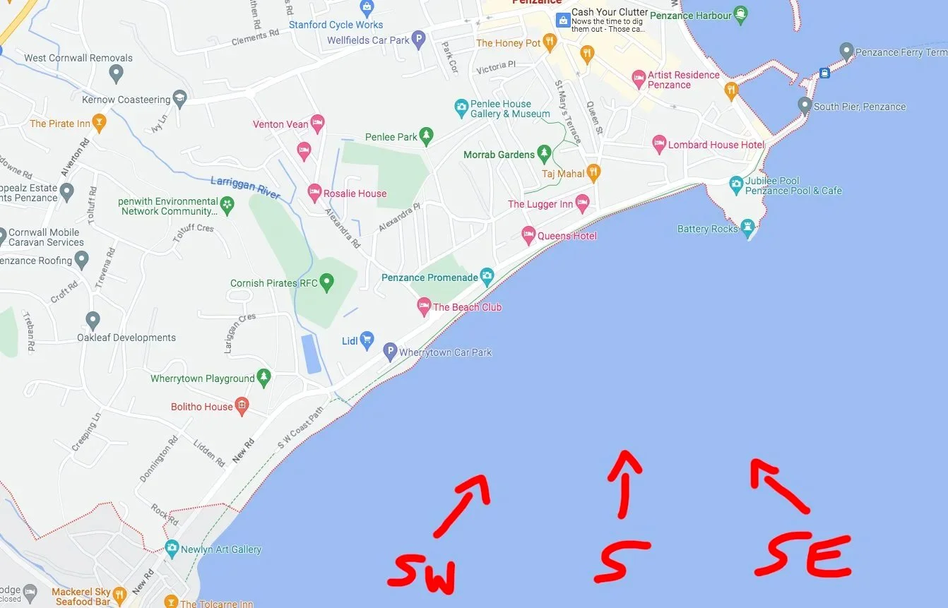
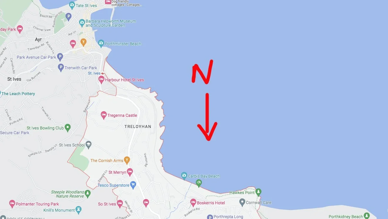
So we’re looking at Penzance sea front / Penzance Promenade. As you can see, by my dodgy scribbles - with a south, southwest or southeast wind, the wind (and chop) will be blowing straight in there. A wind strength of 0-10 kmph won’t produce a great deal of chop. 10-20 kmph will produce a little. 20km+ will start producing enough ‘chop’ to make the swim far more challenging and far less pleasurable. You also need to consider the state of the tide. At high tide the water level is half way up the sea wall. If chop and swell hits the wall it’ll bounce off and send that chop back out to sea. So…if you were swimming at high tide you’d be hit by chop from a few different directions.
START PLANNING when looking at where to swim you should always start the plan at home on the internet. There are a number of different resources that you can use. We like ‘Tides4fishing’, there is also Swimfinder, Windfinder, Magic Seaweed (soon to have a name change), Windy App, Nautide, local to Cornwall is the free My Coast App (I think they’re starting to roll this out nationwide). When looking at these resources you should be checking the wind direction and strength, tide times, swell, you can also look at the weather forecast (avoiding any storms/predicted lightning/drastic wind changes…). Below, we’ll use the Tides4Fishing website. A great starting point would be Swimfinder, which you’ll find towards the bottom of the page.
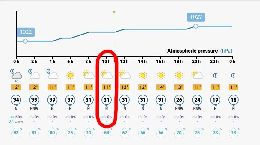
In our example at Penzance sea front, we’re looking at a 10am swim. The wind will be Northerly, at 31 kmph. So, whilst that is a little strong, it’s off-shore for a south facing swim. That means that the wind has no opportunity to influence the conditions, in terms of chop, as the wind only hits the water on the shoreline. You may think that this wind would push you out to sea…if you swim front crawl, there’s a tiny surface area exposed to the wind. This will have minimal impact on the swimmer. If you swam head-up breaststroke and you weren’t such a strong swimmer, you have more surface area exposed to the wind. This may make it trickier to swim back to shore. In this instance, you could plan a high tide swim…so that the harbour wall offers protection from the wind and the off-shore wind blows straight over your head. Next we’ll look at swell. Swell isn’t so much a factor in Penzance (sometimes local knowledge is crucial).

Again, in our example the swell for 10am is around 1.8m. You don’t really get breaking waves in our Penzance example. So whilst this is a decent size swell, breaking waves aren’t a factor. If we go back to the wind direction, we know that it’s 31 kmph from the north. So that wind will be pushing against any swell and flattening it right out. If it were 31 kmph from the south, with a 1.8m swell it’d be a very different story. Anyway, with a strong offshore wind and 1.8m swell there isn’t going to be too much to worry about. The only slight issue you might have is getting in off the slipway at high tide. There may be a little bit of water sloshing around. *At this stage I will point out that the swell section of the website is my least favourite and least accurate. I’ll always double check the swell with Surfline.com. I’ll pick a nearby beach, that faces the same direction…like Praa Sands or Perranuthnoe and check the surf prediction. This will give you a good indication of the swell size.
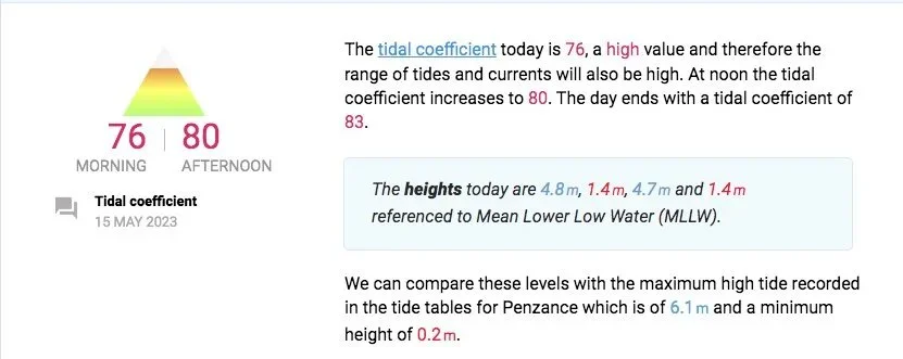
Finally, we’re looking at the tide. At 10am, it’s around a 1.9m tide. Bear in mind that tidal ranges can have massive differences from area-to-area, around the country. You need to specifically look at the area where you’re planning to swim, for accurate tide times and an idea of the tidal range. The ‘tidal coefficient’ is a great feature and gives you a visual representation of exactly how much water is moving around. In our example, it’s 75/120. So it’s not a huge tide but it’s not a small one either. A 120/120 is the biggest possible tide you could experience and a 0/120 would be the smallest. Above, it also gives you a text description of the tidal movement…’a high value and therefore the range of tides and currents will also be high’.
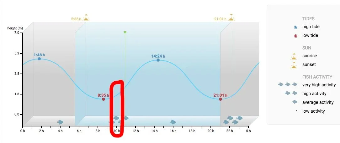
Back to the example swim, a 1.8m tide would make it tricky to get in along Penzance promenade, as it’s quite rocky. You’d have to head for the beach towards Newlyn or swim off the Battery Rocks area, at the back of the Jubilee Pool. If you were the head-up breaststroker we spoke about earlier and were worried about the wind you might wait for the afternoon high tide and get protection from the sea wall along the promenade.
OTHER FACTORS :
land mass. You often get large tidal movements through narrow land masses. You can get this with long narrow beaches or area like Dover. You have water funnelling through narrow gaps or land masses and can get strong currents on an outgoing tide or almost constant lateral currents, as the tide goes in and out.
tides. You have the most water movement in the middle two hours between a high and low tide. These are hours you can avoid. Particularly if you’re experiencing spring tides. If unsure of an area normally best to ‘test’ on an incoming tide, avoiding those middle two hours.
headland. You can experience currents moving around headland and islands, particularly when there’s deep water in these areas. Remember that most people would struggle to make any forward movement against a current as small as 2 knots!
BE FLEXIBLE WITH SWIM LOCATION
Our example location was Penzance sea front. If we look at Carbis Bay (10-15 minute drive away) on the same day. The wind would blow straight in here. It’d really be whipping up some chop and wouldn’t be the most pleasant location to swim in. The swell is coming from the south so you wouldn’t have surf but you would have constant lumpy chop and plenty of it. Had the wind been a strong southerly, Carbis Bay would be prefect. If you aren't fortunate enough to have coastline facing in a couple of directions, it might be a good time to head to the lido or an inland stretch of water.
ADDITIONAL CHECKS
You can always make additional checks if your swim location has a webcam. Just remember that most webcams are wide angle and aren’t always that close to the water. So any chop or swell may look a little smaller than it actually is.
FINALLY…
You can do all the checks in the world at home…but it’s really important to re-check the conditions when you arrive. Ensure that the conditions are behaving in the way you’d expect. Be prepared not to enter the water and possibly have a plan B…just in case.
COURSES
Sea Swim Cornwall have set up an affordable course to teach the fundamentals of planning your swim and understanding the conditions and rip currents. We’re in the process of setting up an online course.
OTHER WEBSITES
SURFLINE, FORMERLY MAGIC SEAWEED
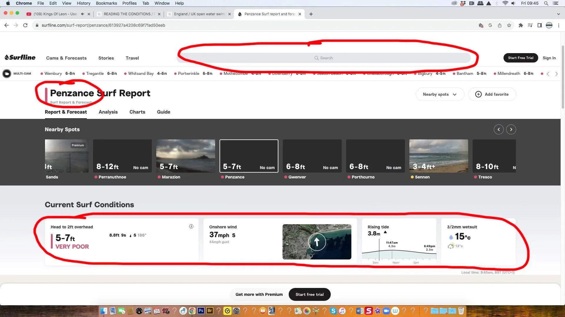
ABOVE : We’ve started by highlighting the search bar at the very top of the page. Put in the location of your swim. Bear in mind that this website is primarily for surfing and if you live in an area that never gets surf/waves, they may not cover your area. I was quite surprised there were search results when I put in ‘Penzance’.
At the bottom of the page I’ve circled a little summary of the conditions. So today we’re looking at 5-7ft of swell, next to the 5-7ft prediction it says ‘9s’ in small text. There’s a 9 second gap between each significant swell. This means there’s a decent swell, with some power. If the gap was really small ie. 2-3 seconds, we’re now really talking about waves with far less power ie. chop or choppy conditions.
We then go onto wind strength and they supply a handy little map that shows you how and where the wind will hit that particular stretch of coast. In this example 37 mph is a significant strength of wind! Below in smaller text you also have the ‘gust’ strength. This can have a real influence in whipping up chop, so is also important. There’s then a small visual representation of what the tide is doing at the time you’re checking and a guide to the water temp.
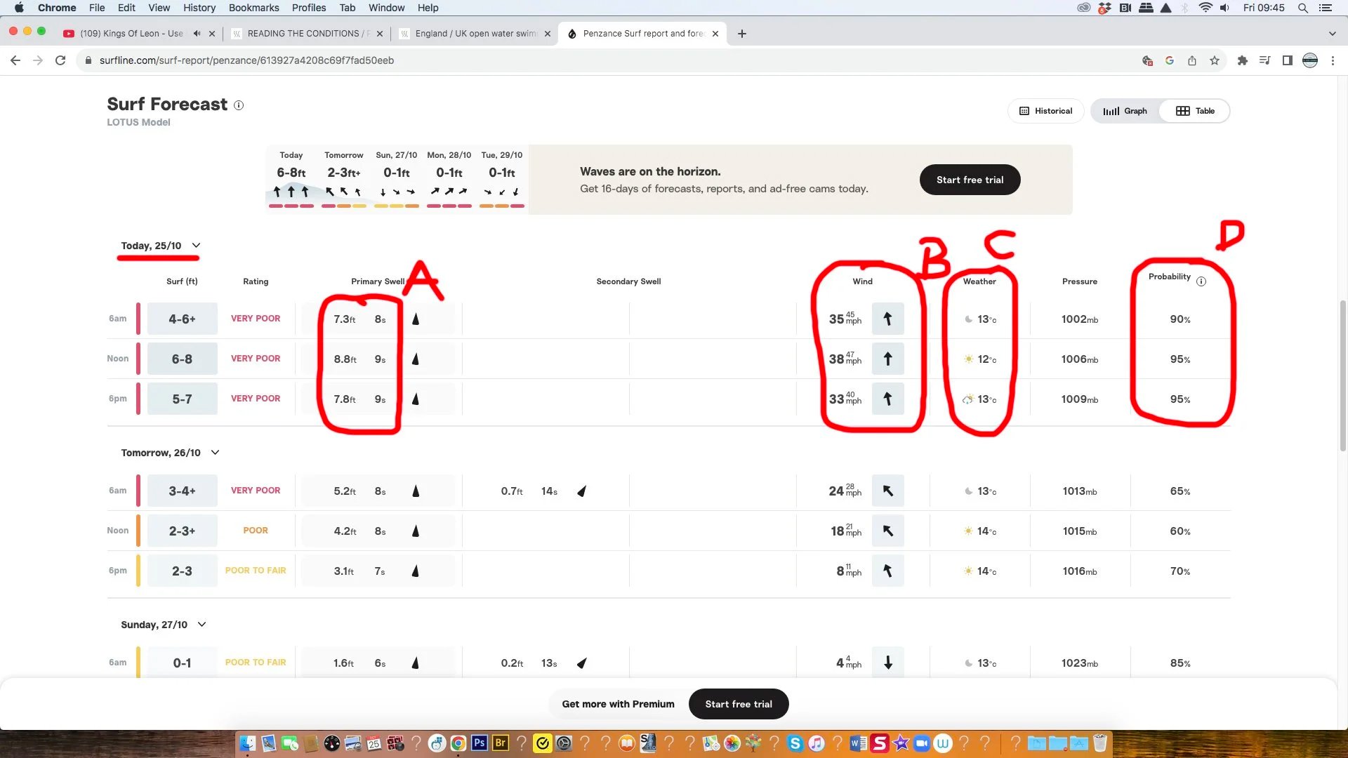
IF YOU SCROLL BELOW THIS INITIAL INFO, THEY GO INTO FURTHER DETAIL:
Figure A - takes you through the changing swell size and wave period through the day. Next to figure A are little arrows. They show you the swell direction.
Figure B - Wind strength through the day and a visual of the direction (arrows).
Figure C - summary of the weather.
Figure D - very handy…goes over the probability that this forecast is accurate. Todays forecast is around 90%. If you look at ‘tomorrows’ it’s only around 65%.
WINDFINDER
When using Windfinder always use the exact area you’re in or intend to swim in. For me, in this example I’ve typed in ‘Windfinder Penzance’. This website primarily focuses on the wind direction and strength. Great if you don’t ever get much swell in your local area but not so good if you do. I like using Windfinder as a secondary check, after using another website that’s better with swell.
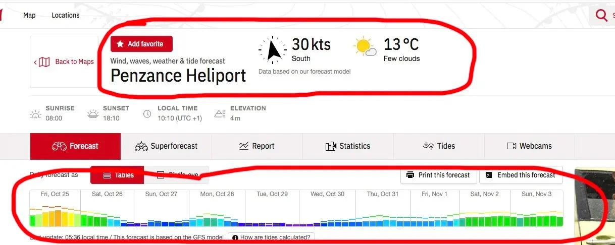
So…they give you an exact location ie. Penzance Heliport, which is a nice central location. They then give you a quick summary of the wind direction and strength….and a summary of the weather.
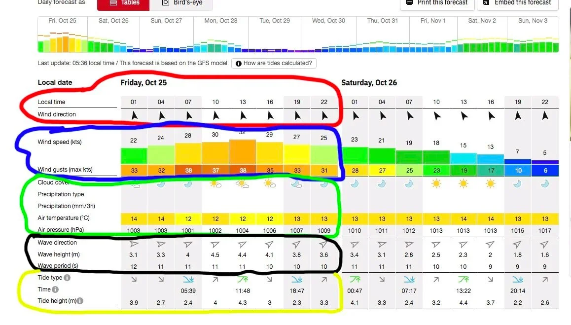
Circled below this is another summary of the wind through the day and it strength. If you look at the Friday (today), it’s strong wind all day, building through the morning, peaking in the afternoon and dropping off in the evening.
Above red circle gives you a visual representation of the wind direction.
Blue circle is wind strength in knots (roughly the same as mph) and then gust strength below.
Green circle really summarises the days weather.
Black circle, goes over swell. This includes a visual of the direction, height in metres and the wave period. So…today it’s 10-12 seconds, which suggests a good strength swell.
Yellow circle at the bottom is the tidal info. This is the bit I don’t really like, as they don’t go into specifics. It’s difficult to figure out the exact tide times etc.
PLANNING A SWIM
Here, we’re really looking at swimming a new route or swim. I’d imagine if you’re a regular at a certain swim location, you’re way past the planning stage. Obviously the above information regarding forecasts relates directly to this section and should be applied, even if we’re talking about your regular, daily swim.
ADVICE :
Local people that regularly swim a route you’re considering are always a great resource, particularly local groups. They typically know any potential hazards, have a good idea of the tides, water traffic, hazards etc. You can use the internet, it’s a great resource…however, there’s no way of knowing who’s giving you the advice and whether it’s good advice or not. It always seems to be the people shouting loudest, that have no idea what they’re talking about. Just be careful with online advice.
FORECAST / WATER QUALITY :
I think we’ve exhausted this section above. Might be worth checking the Surfers Against Sewage (SSRS App) that cover water quality in the sea, real time sewage discharges and have started to cover rivers, on the day of your swim and also to find out if they are any regular sewage discharges locally. The Rivers Trust also have a comprehensive map and good alert system, with regards to river pollution and daily updates.
CAUTION/COMMUNICATION :
Always be super cautious when first swimming at a new swim location.
LAKE/QUARRIES : research safe and reliable entry/exit points, consider water quality, know where there might be under-water hazards, make people aware of where you’re swimming and timings (especially if in remote areas), take a swim buddy or group.
SEA/RIVER SWIMMING - Seek advice, start on in-coming neap tide, swim with friends, have a reliable way of contacting emergency services (list below), keep routes short, have a guide/water support, tell people where you’re swimming, be visible in the water (tow floats/swim caps), consider entry and exit points, swim in favourable conditions…
COMMUNICATIONS :
If you're in a remote area, it’s always a great idea to get the What3words reference.
MOBILE PHONE - lots are now waterproof but they’ll still sink! Waterproof cases might be an idea but they’re not always reliable and it’s often tricky to dial through the case. You can dial the emergency services by tapping the phones power button 5 times in quick succession. Best keeping one in a tow float. Make sure you get mobile reception in the area. You can also activate various gadgets (like the Apple watches) vocally.
VHF RADIO - can be fairly handy but reception isn’t always reliable. They typically work by line of sight. So if you’re surrounded by cliffs, it may not be reliable. You’d also need to research the appropriate channels.
EPIRB/RESCUE BEACON - these are brilliant devices, that work via satellite. They cover approximately 97% of the globe, alerting the appropriate emergency service, sending out your current GPS position. When you register the device, you leave an emergency contact, so that if the device is switched on the contact will be called and can confirm your approx position and plans. The battery on the EPIRB lasts for approximately 7 years. *If you look around, you can get the ‘rescueME PLB1 Personal Locator Beacon’ or something similar from £250. Whilst this may be an expensive option for an individual, it might be a good idea for group swimming.
FLARE - you could consider something like a flare but it seems a little excessive and might have limited success in alerting authorities.
PHONE A FRIEND- you could also get into the habit of phoning a friend pre-swim and then phoning once you’re out of the water. Again, you’d need to check the reception on your phone and it might be problematic if you forget to phone to confirm you finished the swim safely!
SPOTTER - with new swim routes, swimmers from your group could take it in turns to stay on land and contact the coastguard should they need to.
WHISTLE - success with a whistle might be limited, especially in off-shore winds but it’s better to have one than not.
WAVE - coastal/river areas often have dog walkers and people enjoying the beach. Simply stick one hand in the air and start waving and shouting. They can then contact the emergency services.
TIDES :
If you’re looking at extending a daily route, planning a longer, slightly more adventurous swim, trying an entirely new swim…we think it’s always best practice to go on a neap tide. This ensures you’ll have minimal water movement. As discuss in various sections on the website, avoid those middle two hours (between low and high tide). Good idea to go approx 1 hour before high tide (take advantage of slack water). Avoid an outgoing tide, at least initially. You could also kayak or paddle the route thoroughly, to see how or if the water and currents move around. *If you do paddle/kayak the route, ensure you do so on the same tidal state and approx tidal size that you aim to swim it on.
ACCESS (ENTRY/EXIT) :
Be conscious that access and ease of access may vary at different stages of the tide. This is especially relevant, if swimming on an outgoing tide.
ROUTE A & B
I’ve made this heading nice and big for good reason. When planning a new swim or any swim, always figure out a plan A and a plan B. A big problem with swimming and water safety is PANIC. When people panic they don’t think rationally and do something silly! If you plan to start and finish a swim in the same spot but you can’t reach that spot for example, due to a current, rip current, the wind… people start to panic. You frequently see people swimming and paddling against rip currents until they’re exhausted, the rip current being approx 5-6m in width because they’ve stopped thinking and have started to panic. Rather than paddle down the beach slightly (around the rip) and in, they paddle against the current… It’s very easy to say not to panic, much harder to execute.
PLAN B - if you have a plan B, it helps keep that panic at bay. Rather than helplessly exhausting yourself trying to fight the conditions, you have an alternative to focus your energy on. You have to use a bit of logic when it comes to planning this alternative. It might be as simple as an exit point 100m up the beach or possibly swimming around to the next bay…
I’ll also highlight methods of contacting the coastguard (emergency services) here. Much like the ambulance, they’d rather be called and not required, than have someone come to harm… If you have that back-up, you’re much less likely to panic.
Another method of assistance are water users. In Cornwall for example, lots of the surfers are, or have been surf lifesaving members and are more than willing to help. As embarrassing as you might find asking someone for assistance…
‘DRY’ RUN
If you’ve never swum a certain route, you can do all the research in the world but eventually you simply have to swim it. We spoke to Sea Swim Cornwall and they will often attach a rescue board to their ankles, via a leash and then swim the route. Worse case scenario, they get stuck in a current and pop onto the board and paddle to safety. Whilst you may not have a rescue board, a SUP would suffice. Securely attach a dry bag to the ‘board’, include a mobile phone, supplies etc and get swimming. Alternatives might include paddling the route on a kayak or other mode of water craft.